Colca Canyon plunges 4,160 meters into the volcanic rock of southern Peru, 160 kilometers northwest of Arequipa. Andean condors with 2.5-meter wingspans ride the thermal currents above ancient, still-farmed agricultural terraces.
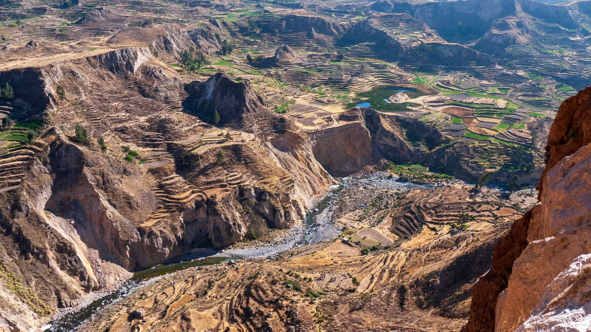
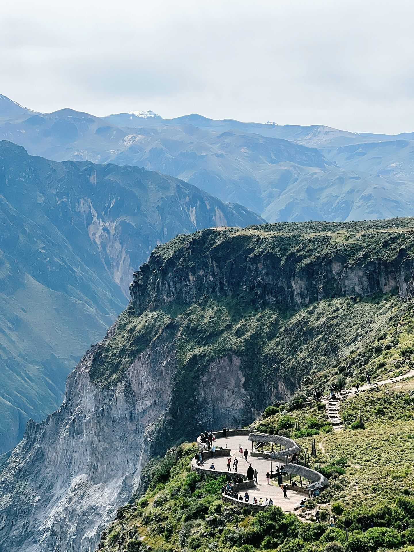
Four thousand one hundred sixty meters of rock, dust, and scrub brush separate the rim of Colca Canyon from the river below. This massive fissure in southern Peru’s Caylloma province stretches for 70 kilometers along a major tectonic fault line. Visitors arrive after a grueling 160-kilometer drive from Arequipa to watch Andean condors glide on morning thermals near the Cruz del Condor viewpoint. The birds pass within meters of the cliff edge, utilizing the rising heat to support their 2.5-meter wingspans. Below them, the Colca River cuts a thin, violent path through the volcanic rock, carving deeper into the earth with every passing century.
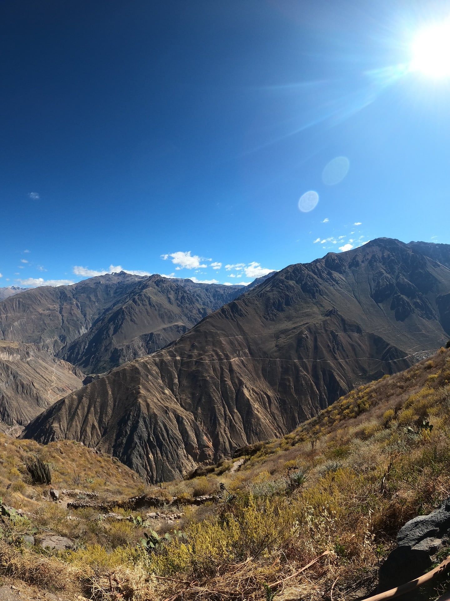
The terrain dictates the experience. Steep slopes angle up to 60 degrees, dropping from the 6,288-meter snow-capped summit of Nevado Ampato down to the 1,800-meter canyon floor. Heat radiates from the ground in geothermal pockets scattered across the valley. Natural hot springs bubble up at La Calera and Llahuar, offering 50°C mineral water right next to the freezing river currents. Hikers navigate narrow, gravel-covered switchbacks that offer zero protection from the intense high-altitude sun. The descent demands physical endurance, but the ascent breaks people. The thin air above 3,000 meters starves the lungs, making every step up the loose scree a calculated effort.
Rain dictates access. Between December and March, heavy downpours turn the loose volcanic dust into slick mud. Trails wash out entirely. Landslides block the single paved road connecting the valley towns of Chivay and Cabanaconde. Travelers arriving in these months often face closed routes, zero visibility, and stranded buses. The dry season from May to November clears the skies and stabilizes the gravel paths, drawing the majority of international trekkers. Hikers who descend to the Sangalle Oasis at the bottom face a brutal, unshaded climb back out the next morning. Mules wait at the bottom for those whose knees give out, costing around S/ 70 in cash for an emergency ride to the top. The physical toll is absolute. Blisters, sunburns, and altitude sickness are guaranteed for those who arrive unprepared. Yet, the sheer scale of the geology forces a shift in perspective. Standing at the rim, looking down at a river that appears as a thin silver thread, the human element shrinks to nothing.
Camelid hunter-gatherers tracked herds through the Colca Valley 8,000 years ago, leaving behind rock art in the Mollepunko caves. By 900 B.C., the Cabanas and Collaguas established permanent settlements along the rim and slopes. They engineered thousands of stepped agricultural terraces, called andenes, directly into the severe inclines. These stone-walled plots allowed them to cultivate potatoes, maize, and quinoa at elevations where frost typically kills crops. They also built colcas—ventilated stone storehouses built into the cliffs to preserve grain. The dry, freezing winds blowing through these high-altitude silos kept food viable for years, ensuring survival during extended droughts.
Inca forces absorbed the valley into their empire in the 14th century through a mix of military pressure and strategic marriages. They utilized the existing terrace systems and introduced new administrative structures, redirecting the valley's agricultural surplus to feed their expanding armies. High-altitude peaks became sacred sites for state-sponsored rituals. On the 6,288-meter summit of Nevado Ampato, Inca priests sacrificed a young girl known today as 'Juanita' to appease the mountain gods. Her frozen body remained perfectly preserved in the glacial ice until 1995. Spanish conquistadors arrived in the 1540s, fundamentally altering the valley's layout. Viceroy Francisco de Toledo forced the dispersed indigenous populations into centralized towns like Chivay, Yanque, and Coporaque to extract taxes and enforce Catholic worship. The 18th-century baroque church in Yanque stands directly on top of earlier indigenous foundations, a physical marker of the colonial transition.
The canyon remained largely isolated from global mapping until the late 20th century. A dirt road finally connected Chivay to Arequipa in the 1940s, primarily to serve local silver and copper mines. In May 1981, a Polish rafting expedition led by Andrzej Pietowski dragged their boats past Cabanaconde. They spent weeks navigating Class V rapids through the narrowest, deepest sections of the gorge, dodging rockfalls and surviving on limited rations. Their measurements proved the canyon dropped 4,160 meters into the earth. The Guinness Book of Records officially recognized Colca as the world's deepest canyon in 1984, sparking the first wave of international tourism. Today, descendants of the Collagua and Cabana still farm the original pre-Inca terraces using the same gravity-fed irrigation channels. Visitors must pay a S/ 70 Tourist Ticket in cash at the Chivay checkpoint to enter the region, as credit cards fail without reliable internet.
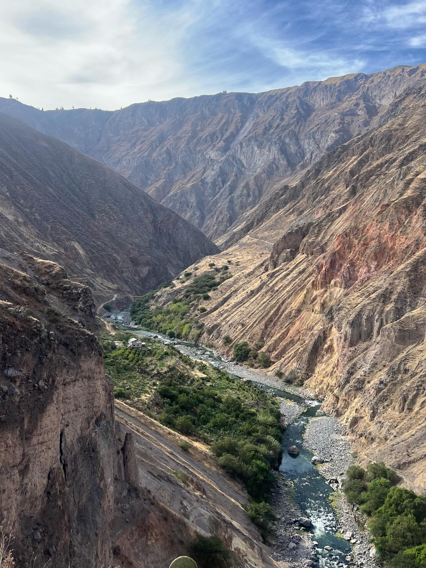
Volcanic activity and millennia of water erosion carved the 4,160-meter drop of Colca Canyon. The Colca River cuts directly through layers of basalt, andesite, and rhyolite along a major tectonic fault line. The canyon walls rise at brutal 60-degree angles, creating a V-shaped gorge that traps heat at the bottom and funnels freezing winds across the top. Vegetation clings sparsely to the upper rims, dominated by dry ichu grass, thorny shrubs, and hardy yareta plants that grow just one millimeter per year. At the canyon floor, the environment shifts drastically. The Sangalle Oasis relies on microclimates trapped deep within the gorge to support palm trees, bamboo, and lush green foliage, contrasting sharply with the arid desert slopes above.
Geothermal energy vents constantly throughout the valley. Magma chambers from nearby active volcanoes, including Sabancaya, Ampato, and Ubinas, heat underground aquifers. This boiling water forces its way to the surface, creating fumaroles, geysers, and natural hot springs along the riverbanks. The commercial pools at La Calera maintain temperatures between 36°C and 50°C, while wild, undeveloped springs near Llahuar bubble up directly beside the freezing river currents. Heavy sulfur deposits stain the surrounding rocks yellow and white, filling the air with a distinct, sharp odor.
The extreme elevation changes create distinct ecological zones within a few horizontal kilometers. The Patapampa Pass sits at 4,900 meters, where the air holds roughly half the oxygen found at sea level. Herds of wild vicuñas and domesticated alpacas graze on the sparse vegetation of the Salinas and Aguada Blanca National Reserve nearby. Down at 970 meters in the Andamayo Gorge, temperatures spike and the river widens into a slower, muddy flow. Hikers descending from Cabanaconde at 3,287 meters navigate trails composed entirely of loose volcanic dust and scree. A single misstep on the steep switchbacks sends rocks tumbling hundreds of meters down to the river. Trekking poles are mandatory gear to prevent knee injuries on the relentless downward gradients. The rock formations themselves tell a violent geological story. Basalt columns stand like petrified forests along the middle sections of the gorge, created when ancient lava flows cooled and cracked into hexagonal pillars. Earthquakes frequently rattle the region, sending fresh rockfalls down the cliffs and constantly reshaping the narrowest sections of the riverbed.
The Collagua and Cabana people shaped the physical landscape to match their survival needs, and their descendants maintain those exact structures today. The stepped andenes cover thousands of hectares along the canyon walls, forming a massive geometric grid visible from space. Farmers still repair the ancient stone retaining walls by hand and rely on gravity-fed irrigation channels engineered over a thousand years ago. These terraces prevent soil erosion on the severe slopes and create microclimates that protect crops from overnight freezes. The agricultural calendar dictates the rhythm of life in the valley, with entire villages mobilizing for the planting and harvesting of quinoa, maize, and over fifty varieties of native potatoes.
Andean condors hold deep spiritual weight in local mythology. Indigenous belief systems view the condor as the ruler of the Hanan Pacha, the upper realm of the gods. The birds act as messengers between the living and the divine, carrying the spirits of the dead to the afterlife on their massive wings. Locals gather at the Cruz del Condor viewpoint not just for tourism, but to observe the health of the local population. A decline in condor sightings often signals ecological imbalance or approaching drought. Ritual offerings of coca leaves and chicha are still left at high-altitude passes to ensure safe travel and honor the Apus, the mountain spirits.
Traditional dress remains standard daily wear in villages like Yanque, Maca, and Sibayo. Women wear elaborately embroidered skirts and distinct hats that signal their specific ethnic lineage and marital status. Collagua women traditionally wear white hats adorned with ribbons and sequins, while Cabana women wear intricately embroidered cloth hats. The intricate threadwork depicts local flora, fauna, and geometric patterns passed down through generations of weavers. Visitors attending morning markets in Chivay can buy local remedies like emoliente, a hot, thick herbal drink brewed with toasted barley, flaxseed, and medicinal mountain herbs. Music and dance also serve as living records of the valley's history. The Wititi dance, recognized by UNESCO as Intangible Cultural Heritage, features men dancing in women's clothing—a tactic historically used to confuse rival tribes or Spanish conquerors during battle. Brass bands play relentlessly during the February carnival season, echoing off the canyon walls for days.
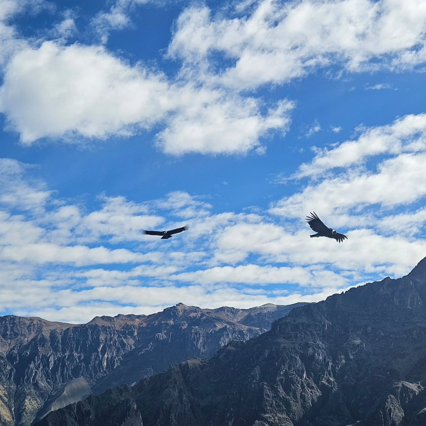
Andean condors wait for the morning sun to heat the canyon air, creating thermal updrafts they need to lift their 15-kilogram bodies.
Mountaineers discovered the frozen Inca mummy 'Juanita' on Nevado Ampato in 1995 after volcanic ash from a neighboring peak melted her ice tomb.
The pre-Inca cultures built colcas (stone storehouses) directly into the cold, windy cliff faces to naturally refrigerate their crops.
The high-altitude plateau above the canyon is a protected sanctuary for wild vicuñas, whose wool is considered the finest and most expensive in the world.
The natural hot springs at La Calera reach 50°C and are heated by magma chambers from the active volcanoes surrounding the valley.
The physical checkpoints and ticket offices in Chivay do not accept credit cards due to a lack of reliable internet infrastructure.
At 4,160 meters deep, Colca Canyon plunges more than twice as deep as Arizona's Grand Canyon.
Colca Canyon drops 4,160 meters (13,648 feet) from its highest peaks to the river below. This measurement makes it roughly twice the depth of the Grand Canyon in the United States.
Non-Latin American foreign adults must pay S/ 70.00 (approximately USD 19.00) for the Boleto Turístico Colca. Latin American adults pay S/ 40.00, and children aged 6 to 15 pay S/ 20.00.
No. Ticket offices and physical checkpoints in Chivay require exact payment in Peruvian Soles (PEN). Credit cards are not accepted anywhere at the entrance gates.
Condors are most active between 8:00 AM and 10:00 AM. The rising sun warms the air inside the canyon, generating the thermal currents the birds use to glide along the cliffs.
Heavy rains hit the region from December through March. During these months, trails become slick with mud, and flash floods frequently block the main roads connecting the valley towns.
The canyon rim sits above 3,000 meters, requiring acclimatization. Spend two to three days in Arequipa before your visit, drink coca leaf tea, and avoid heavy meals or alcohol.
Most descents into the canyon begin at Cabanaconde, a town located at 3,287 meters elevation. From there, steep switchbacks lead down to the river villages of Sangalle, Llahuar, and San Juan de Chuccho.
Locals rent mules and donkeys in Cabanaconde for hikers unable to manage the steep ascent. A local bus also runs from the dirt road near Llahuar back to Cabanaconde around midday for S/ 10.
Drones are strictly prohibited without official commercial permits. The noise and flight paths disturb the endangered Andean condors and violate local wildlife protection laws.
The Collagua and Cabana cultures engineered the stone terraces around 900 B.C., long before the Inca empire existed. Local farmers still use these exact structures today to grow potatoes and quinoa.
Browse verified tours with free cancellation and instant confirmation.
Find Tours